


Information about the Weather Station
The weather station in use is a Davis Vantage Pro 2 AWS (Automatic Weather Station) with fan aspirated radiation shield, measuring air temperature, relative humidity, rainfall (intensity and accumulation), wind speed/direction, and solar radiation. From these many other variables (Dew point, wind chill etc) are calculated. The console that receives the information also measures air pressure and transfers data to the computer and via software to the web.
In addition, rainfall measurements are made using a manual ‘CoCoRaHS’ rain gauge that is used to correct totals from the AWS. These gauges have been shown to have very good accuracy over annual timescales (better than the tipping bucket gauge of the AWS).
Site Details:
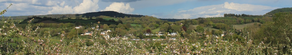
The weather station is set up in a typical back garden, located on the edge of a small village (Harpford). It is bordered on the NW side by fields and the SE side by other houses. Topographically, the station is sited in on the floor of the North-South oriented Otter Valley, with associated influences such as cool nights, and some bias to wind direction and speed.
The station benefits from decent siting and exposure for a personal weather station, although it does come with a few slight limitations that one may expect. For example;
- The ISS is pole mounted above a fence, which in calm sunny conditions could lead to a slight over-read of temperature due to warm air rising off the fence (though this seems to be relatively minor, and any general over-reading is reduced by a fan aspirated radiation shield).
- Wind measurements are slightly affected by surrounding obstacles (also see below), as siting the anemometer at the official standard of 10 metres is not practical.
Height of temperature/humidity sensors: about 1.7m above the ground, in a fan aspirated radiation shield (passive shield prior to March 2012).
Height of rain gauge: AWS gauge about 2m above the ground, supplemented by a CoCoRaHS rain gauge mounted at 30cm.
Height of anemometer: about 7.5m above the ground (This was at about 5.3m until the 8th January 2011)
Station Elevation: 26m above mean sea level.
Some photos of the weather station and its surroundings can be seen below.
Significant Updates:
8th January 2011 - the anemometer was raised from 5.3m to 7.5m above the ground. This helps reduce some of the sheltering from houses to the SE and S, and trees to the NE, however some influence still remains (mounting the anemometer higher than this, at the official 10m standard is not practical).
March 2012 - A new ISS was installed, this time with 24 hour FARS (Fan Aspirated Radiation Shield) which reduces any overheating in sunny calm weather (though this didn’t seem to be much of an issue here), and also improves sensor response time in light winds, which can be useful with sudden temperature changes or on clear calm nights, better resolving temperature fluctuations.
March 2015 - A solar radiation sensor was added, recording ‘global horizontal irradiance’, which also allows estimation of sunshine hours, along with calculation of THSW index (Temp-Humidity-Sun-Wind Index) and Evapotranspiration.
February 2016 - A replacement ‘third party’ Temp/hum sensor was installed, with better specs and a faster response time than the original Davis sensor. From August 2009-February 2016, humidity often over-read by around 5-7% with humidity below about 90%.
July 2016 - The latest ‘SHT31’ Davis temperature/humidity sensor was fitted, with improved accuracy especially at lower and higher temperatures.
| Summary |
| Live Gauges |
| Graphical/old format |
| Today/Yesterday |
| Interactive graphs |
| Static Graphs |
| Data Tables |
| Records |
| 'Reports' archive |