


Stream and river flood risk forecast covering the next 5 days or so..
These forecasts gives my thoughts if I expect a flood risk over the next 5 days or so based on various weather forecast and model data, along with local knowledge. It is often very hard to predict flooding from streams with small catchments, as this often depends on whether (for example) localised intense bursts within a rain band fall on the catchments as apposed to missing by a few miles. This means risk levels may not often exceed slight or moderate for the stream before flooding occurs. The stream needs pretty heavy rain (of a high enough amount) to flood, whereas the river can flood from continuous more moderate rain giving large daily totals. Note: I may not always be around to update this, so please do not ignore any Environment Agency warnings.
Please refresh the page to ensure you are viewing the latest forecast and not an older version stored in your browser’s cache.
Please refresh the page to ensure you are viewing the latest forecast and not an older version stored in your browser’s cache.
Flood Risk key:
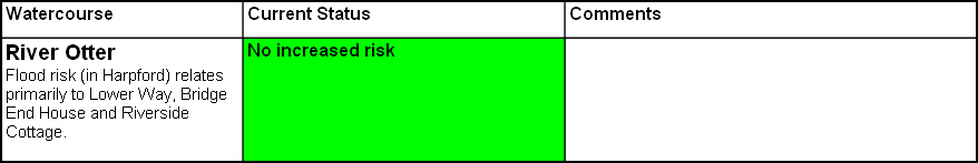
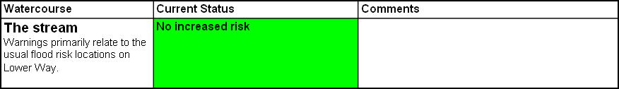
No Increased Risk - no risk of flooding envisaged (based on current forecasts and model output)
Marginal Risk - minor chance of flooding - 2-10% risk.
Slight Risk - 10-25% chance of flooding.
Moderate Risk - 25-50% chance of flooding.
High Risk >50% chance of flooding. Confidence of actual flooding more than a few hours before it occurs is not often this high.
Exceptional Risk - Rarely used - issued when there is a significant chance of an exceptional event occurring.
No Increased Risk -
Exceptional Risk -
Last forecast update: 23/11/2016 at 10:30